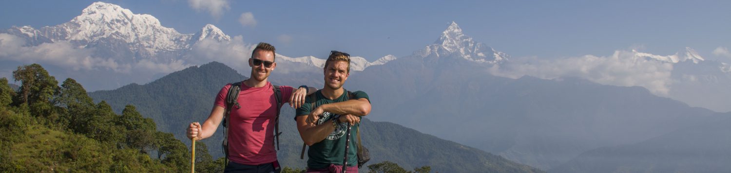

We knew from the moment we planned our trip that trekking in Nepal was top of the agenda, but we had no idea how dangerous it could be. The Annapurna Massif is a group of mountains, part of the Nepalese Himalayas. The tallest peak, Annapurna I is 8091m (which is exactly six Ben Nevis’s on top of each other). Trekking around the Annapurna region has become a major industry and draws tens of thousands of visitors to Nepal. Because of these numbers, basic accommodation in the form of ‘tea houses’ have sprung up in the mountain villages, providing decent meals and sometimes decent beds – you can even hire a porter to carry all your bags for you through the mountains (if you enjoy watching other people suffer). This infrastructure betrays the fact that trekking in the highest mountain range in the world is risky – avalanches, rock falls, altitude sickness and hypothermia claim lives every year. These risks made it all the more appealing. Keshab at the Shangri-La Boutique hotel recommended the Annapurna Sanctuary trek – 10 days, which takes you to the Annapurna Base Camp at the foot of three of the most impressive mountains in the range. Anthony and I have both been above 5000m with only mild effect of altitude sickness in Ladakh, India. The 4100m of Annapurna Base Camp would surely be easy then, right?
The Guide
$60 per day per person got us all of our accommodation and meals in the tea houses (you have to buy your own drinks), park permits, and most importantly, a guide. Indra Gurung was ours. He is a diminutive, smiley man who, over the course of our 9 days, regaled us (and anyone else who would listen) with countless hilarious stories about former clients (including a German who liked to get naked to shock Korean girls), Nepalese insights about global affairs (“Donald Trump has so much blah-blah”) and general good banter. He also called ahead to make sure we had accommodation at each of our stops and he carried enough bananas, guavas and apples to present us with a lovingly made fruit platter after every single meal for the whole 9 days. He soon became a legend not only with us, but all of our fellow travellers. Even after we and all the other exhausted trekkers went to bed, we could hear the villagers roaring with laughter as Indra (after a few glasses of Roxy – locally produced millet “wine”) told his stories. We soon called him the Happy Buddha. We couldn’t imagine our trek without him.

On the morning of the first day we were taken by taxi from Pokhara to the drop off point for the Annapurna Sanctuary trek, a small town called Nyapul. We could see from the masses of North Face clad westerners assembled by the road that this really was peak trekking season. Once we set off, the crowds thinned to a consistent yet manageable trickle which would remain throughout our 9 day journey. The first few hours walk is a gradual ascent along dirt roads from the floor of the green, forested valleys, across cable suspension bridges over cascading river rapids, and through flower peppered villages at the edge of terraced rice fields. It was pleasant walking, but after lunch, the true nature of this expedition dawned on us: an uninterrupted 3300 step elevation to our first stop,the village of Ulleri. It was a full-body physical challenge. The 7kg we were carrying on our backs felt closer to 70 by the end.
Teahouse Life
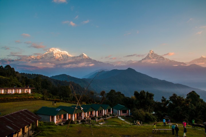
Night one was spent in Ulleri, the first of many Himalayan villages whose existences were forever changed by the arrival of the tea house trekkers in the 1970s. Where once only buffalo stables and squat stone houses clung to the steep edges of the valleys, now loomed multitudes of blue corrugated iron and plywood guesthouses with names as varied as “Annapurna View Lodge, “View Annapurna Lodge” and “Lodge with Annapurna View.” While Indra managed to wangle us a private room (no mean feat in high season), the walls were barely existent and the windows were so drafty that they might as well not have bothered. This slapdash construction is excusable however when you see the procession of exhausted porters all the way along the route. There are no roads here. All building materials must be carried by hand or by head, so leave your usual expectations of holiday accommodation very much in Pokhara. Having come to terms with this we were able to enjoy the charms of trekker tea-house life. It goes a bit like this: order your dinner at 5 from the same menu at every stop, wrap yourself up in all of our your clothes then huddle together in the dining room with other trekkers and swap trekking stories or play cards until bed at 7:30. Sleep is needed.
The Highs
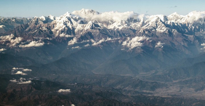
Dawn brought our first clear views of the snow-capped mountains of the Annapurna range. The first orange light of the sun as it rose over the foothills made the jagged edges of Machapuchare mountain look like it was on fire. The breathtaking scale of the scenery of Annapurna can’t really be summed up in words or pictures, but Will had a damn good stab at it – 1166 photos were taken on this trip. The paths take you up and down (and up and down and then up and down again) the sides of valleys and along the tops and bottoms of cliffs, over and a under waterfalls which thunder down from miles above, through rhododendron forests, across dizzying cable bridges and through barren tundra. All the while, tantalising glimpses of snow-capped peaks loom above. In October, the skies are normally clear in the morning giving clear views, but clouding over by midday. Mostly, the walking temperature was pleasant, perhaps a little cold if you stopped in the shade.


It was a 4:30 start on the third day at Ghorepani (day 3) to see the sunrise from Poon Hill, a 3200m vantage point which promises stunning views of the entire Annapurna range. Ant was beginning to feel the effects of the altitude here and was advised by Indra to stay in bed to help him acclimatise. So Indra and Will took the 3000 steps to the top of the hill. The sun coming up over the foothills to the East was spectacular as it cast long, straight beams across the landscape, but it was clouds allowed only brief glimpses of the whole range. Perhaps more amazing was the number of people able to squeeze onto the top of one small hill. If you didn’t know otherwise, you’d think you were at a North Face convention – make sure you get here early to secure a good spot so you’re view isn’t obscured by selfie sticks.


The Lows
Aches in our legs and backs appeared on day two, but they disappeared by day four, realising there was no point in complaining any more. It was on day five, however, that we really started to get high (above 3000m), and things became difficult again as the air grew thinner. The landscape changed from friendly to threatening: forests and rice fields thinned to scraggy shrubs and boulders, the soft curves of the valley turned into sheer, jagged walls. There were helicopters constantly buzzing back and forth along the final valley ascent to the Annapurna Base Camp (ABC). Indra told us that several people per day are evacuated due to acute altitude sickness – at $2000 per trip. He began to tell stories of people disappearing without a trace, others falling off cliffs, others suffocating while coughing up blood, and his experience of dragged bodies out of rivers. Only then did the danger of our pursuit really dawn on us.
Deurali (day 5) was supposed to be our last stop before the final ascent to base camp. It’s a bleak village with only three guesthouses where the cold pays no attention to how many of layers of winter clothes you wear. The atmosphere here is different too – people are no longer jolly and sociable, it gets tough and people drop like flies as they succumb to the altitude. At about midnight, Ant left our shared room to go the outside toilet. He came back with blood all over his face and a nasty bump on the head; he had blacked out and fallen due to the altitude. We woke Indra (along with half of the porters and guides sleeping in the dining room) and we cleaned his cuts on the path outside. Ant slept in the dining room so Indra could keep an eye on him kept him throughout the night.
Change of Plan
The next morning, Indra made the decision that it would be too dangerous for us to continue to base camp – an additional 1000m climb. He decided to take us to Australia Camp instead, with equally stunning views but at a much lower height. The next morning, after Ant was given garlic soup as his medicinal breakfast, we descended from Deurali with a sense of disappointment not to have reached the base camp, but the experience taught us a valuable lesson about the unpredictable nature of altitude sickness. It doesn’t matter if your old or young, fit or fat, it affects people in different ways, each time they ascend or descend. We walked back through the same valley as we had the day before, a little earlier than planned but Ant felt better as we descended. We stopped at Jinhu (day 7) on the way through to take advantage of the natural volcanic hot springs here. For 100 npr (70p) you can soothe your aching muscles in the hot water funnelled into three pools next to the rapids of the River Modi. Get there early, however, as the tranquil spot becomes a circus of human flesh as the backpackers, their porters and guides pour in in the afternoon. Our final destination, Australia Camp (day 8) is a chilled out settlement with stunning views of the entire range and is worth taking a detour to even if you did make it to Annapurna Base camp. In my view, the sunrise was more impressive here than at Poon Hill, it’s less cold, and there are no crowds. Above all, it’s only 1500m, so there is no danger of passing out if you stand up too quickly.
Our trek in numbers
161 km walked
26,652 steps climbed
35,366 calories burned
1,166 photos taken by Will
1 slightly damaged face – Ant

Hope the slightly damaged face is all back to full smiles, Ant! X
LikeLiked by 1 person
Supperficial damage……ego more battered than my face! A x
LikeLike
Love it!
LikeLike
Both look good carry on enjoying
LikeLike